
*Editor's Note: This post is part of a weekly series titled the Promised Land where author David G. Woolley sheds his bloggish sensibilities and delves into the research and inspiration behind the characters and story lines of his Book of Mormon Promised Land Historical Fiction Series. This week it's ancient borders.
The Northern Hejaz. That's what Arabs call these towering peaks and deep gorge-like valleys. For centuries nomadic kin-group tribes carved out their sheikdoms here. We call them mountains. Ancient sheiks called them Borders. Nephi was even more distinguishing, calling them Borders near the Red Sea and Borders nearer the Red Sea. It was a word so descriptive of the territorial nature of geographic landmarks that it endured for millenia. An elegant word choice by Book of Mormon scribes born of the dual nature of these mountains. They were the dominating feature of the land. They were also the territorial boundaries of nomadic kingdoms.
Hejaz translates literally as partition or barrier, but since sheiks in these mountains determined the limits of their kingdoms by claiming territory that fell within view, the word Borders is the preferred translation. The lands as far as a sheik could see from one ridge to the next became soverign territory. The lands beyond view were left to the claims of neighboring sheiks. (Joseph Catafago, “Arabic-English Dictionary.” See also: The New Roget’s Thesaurus, Revised Edition, ed. Norman Lewis, “Boundary,” 49).
In this interactive topographical map you can see the split nature of the Northern Hejaz. At the top of the map near the city of Aquaba the coastal mountain chain and the inland mountain chain appear as one. Zoom in a little closer and you'll see a fairly distinct separation of the two chains where the ancient trade route once ran and where a modern highway runs today between Al-Humaydah and Al-Bad. The coastal chain runs along the east shores of the Gulf of Aquaba before ending near the southern extreme of the gulf. The inland chain continues further south, veering eastward and mixing into the brownish yellow desert sands of central Saudi Arabia.
View Larger Map
Nephi was likely referring to these border mountains when detailing the route his family followed to the Valley of Lemuel:
And he came down by the borders near the shore of the Red Sea; and he traveled in the wilderness in the borders which are nearer the Red Sea; and he did travel in the wilderness with his family, which consisted of my mother, Sariah, and my elder brothers, who were Laman, Lemuel, and Sam (1 Nephi 2:5).
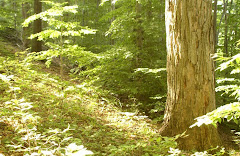
Right here in a previous post titled An Ancient Setting for the Tree of Life you can read about the Valley of Lemuel in the Northern Hejaz pictured below. A river runs through the wadi known as Tyib al Ism, cutting a deep canyon through the Hejaz and emptying into the Gulf of Aquaba.

Nephi recorded that they called the name of the river, Laman, and it emptied into the Red Sea; and the valley was in the borders near the mouth thereof (1 Nephi 2:8). Go back and take a look at the interactive map and you'll notice that the southern half of the coastal chain of the Hejaz drops directly into the gulf waters just as Nephi described. Wadi Tayib al Isam is located directly east across the gulf from the Wadi Dahab (Click in a little closer to find the present day names).
The British explorer David Hogarth wrote that "During the British occupation of these territories, military mapmakers used the name Northern Hejaz in their maps, journals, and geogrpahic explorations as the proper name for the range (David George Hogarth, “Hejaz before World War I, a Handbook”). Its no wonder that scholar Hugh Nibley complained that somewhere between Joseph Smith's dictation of the proper name for these mountains to his scribes, Oliver Cowdery and Emma Smith, and the subsequent editing by the printer of the Book of Mormon, E.B. Grandin, the name was reduced to a lower case noun. The uppercase usage of Borders implies the proper name for this mountain range, while the lowercase usage connotes any geographic boundary, desert, plateau, or wadi. Who in 19th century Palmyra knew?
Hejaz are not limited to only mountains. Any geographic barrier or partition that acts as a boundary between different geographic climes, establishes territorial rights, or separates people of different languages or cultures acts as a Hejaz. The wide sweeping deserts of central and southern Saudi Arabia separating the inland cities of Mecca and Medina from the Red Sea. The Judean Wilderness. The Andes. The Colorado River's Grand Canyon. The Sahara Desert. The Mississippi River. The Gulf coast. The Himalayas. The Florida Everglades. These are only a few of the world's notable Borders.
The Book of Mormon is filled with Borders, all of them notable Nephite landmarks. based on my research, it appears that Nephi and his descendants in the New World continued using the term as it was used in the Old World.
The following three and a half minute video clip begins with an aerial view of the south west coast of Guatemala, the location where Lehi and his family likely made their landing in the New World. They called this coastal area the Land of First Inheritance. It was also along this coast where Lamanites attempted to circumvent the inland border mountain chains surrounding the Chiapas Central Depression and attack Nephite lands from a northly position. This introductory video clip from Journey of Faith, The New World produced by the Neal A. Maxwell institute's Foundation for Ancient Research and Mormon Studies, provides excellent footage of mountain, river, sea and swamp borders in northern Guatemala and southern Mexico along with commentary by LDS scholars about Lehi's arrival to Mesoamerican and the geography they likely encountered.
This interactive map of southern Mexico and Northern Guatemala below details what scholars call the Chiapas Central Depression. Its that light green area in the center of the map with a long finger-like body of water behind the Angostura Dam. This depression is what scholars believe is the most likely location of the Land of Zarahemla and the mountains surrounding the Central Depression are the Borders of the Land of Zarahemla.
View Larger Map
During Alma's missionary circuit of the greater Land of Zarahemla's Central Depression (Alma 6-16), he ascended the slopes near the headwaters of the Sidon River in the south east Borders to Gideon somewhere near present day Guadalupe (click in closer to find Guadalupe on your map). Next he headed north west through the higher elevations of the Borders to avoid the deep gorges at lower elevations and preached in the Land of Melek located in the Central Depression's south west coastal mountains near present day Sierra Madre de Chiapas (two clicks gets you close enough to find the present day location).
Alma left Melek and traveled to the most storied city of his mission excursion, the Northern Borders of the infamous city of Amonihah near present day Las Mercedes, the city where he befriended Amulek. He finished his approximately 6 month mission by heading through the upper mountain elevations of the Central Depression's extreme north west borders to Noah. He never reached Aaron located somewhere in the mountains further north of Noah as he had planned. Alma then descended the slopes to Sidom in the Sidon River Valley near present day Tuxtla Gutierez. Instead of returning home along the Sidon River through difficult-to-traverse cross canyons and gorges, he headed up into the mountains along the north east Borders of the Central Depression following the ancient trade route of his day before descending to Zarahemla near the head waters of the Sidon.
Beneath the waters of the Angostura Dam lay the ancient ruins of Santa Rosa, the most likely site for the City of Zarahemla. Before it was covered with water, archeologists determined that the city was home to two different kin groups. One group migrated up stream into the Central Depression Borders from the gulf coast some time between 550 B.C. and 300 B.C., bringing with them their customs and their Zoquen language--a language that survived from the Olmec/Jaradite tradition and influenced languages along the same gulf coast borders until the arrival of the Spanish armies. Moroni is a Zoquen/Jaradite name meaning "one from Moron", the Jaredite capital.
The second language group populating Zarahemla migrated there from Guatemala City, the most likely site for the City of Nephi, entering the Central Depression near the headwaters of the Sidon River south eastern Border mountains. This group spoke one of the ancient Mayan dialects and brought with them their highland Guatemalan customs and religious beliefs. These two groups joined together, sharing government power and religious practices. A plaza stands in the temple center of Santa Rosa where ancient inhabitants laid down two distinct types of gravel with a line down the center in remembrance of the coming together of these two distinct language groups. Scholars believe these groups are the ancient Mulekites and Nephites mentioned in the Book of Mormon.
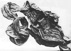
.jpg)
The headwaters of this major river, the Grijalva, gathers in the Borrder mountains in the south east quarter of the Central Depression, flowing north east past the ruins of Santa Rosa. At about the 2:47 minute mark in the video featured above you get a bird's eye view of the Grijavla/Sidon river. The main branch continues north east out of the Central Depression and runs through swampy coastal plain Borders in lands the Book of Mormon calls the most principal parts of Nephite territory where major Nephite cities were located before emptying into the Gulf of Mexico. In the above photo you're in the middle portion of the river, leaving the Central Depression and heading through the difficult-to-traverse gorges near Tuxtla Gutierrez/Sidom on the way down river to the swamp infested coastal regions of Nephite territory.
At Guatemala City scholars have uncovered these ruins known as Kaminaljuyu, the most likely location for the City of Nephi.

In the interactive map below you can find Guatemala City/Nephi in the lower right hand corner. Notice the nearly two hundred miles of difficult-to-travel Borders separating the City of Nephi from the Central Depression/Land of Zarahemla in the upper left hand corner of the map. It took Mosiah and his people about twenty one days to negotiate the 225 miles of this mountain wilderness. Book of Mormon authors referred to these mountains as wilderness and also as the Borders of the Land of Zarahemla and the Borders of the Land of Nephi depending upon how close you are to Nephite or Lamanite territory. Only a single known route in the higher elevations allowed for unhindered northward-southward travel and the modern Guatemalan highway CA1 follows that ancient route. No wonder this mountainous Border wilderness served as an excellent barrier between ancient Nephite and Lamanite civilizations.
View Larger Map
Moroni hid his spies and positioned his forces in these mountain Borders . Alma built the city of Helam here. The preists of King Noah escaped into these Borders. Outside of Helam, there was little arable land capable of supporting a sizable population. Small nomadic groups and warrior bands roamed these Borders, hunting and eating off the land, but large populations and armies could not survive in these mountains without food supplies.

The Lamanites twice attempted to surprise the Nephites by travelng along this west coast Border beach and attacking the Nephites from the north by way of the northern coastal mountain borders. This video clip begins with a view of this west coast border shoreline running from Gautemala into southern Mexico. The Lamanites were never able to penetrate Nephite territory beyond Amonihah. They likely ran out of food supplies.

Converts were baptized in the shadow of these volcanic Borders on Lake Atitlan. I, Alma, having been consecrated by my father, Alma, to be a high priest over the church of God, he having power and authority from God to do these things, behold, I say unto you that he began to establish a church in the land which was in the Borders of Nephi; yea, the land which was called the land of Mormon; yea, and he did baptize his brethren in the waters of Mormon (Alma 5:3).

In this interactive map below you'll find that south of Guatemala City (the City of Nephi) you descend onto the plains of Shemlon and Shilom before arriving at Lake Atitlan, the most likely candidate for the Waters of Mormon and the adjacent Land of Mormon. King Noah built a tower to see down through these descending valleys.
If you examine the map closely, you'll find a flood plain across the lake from Durazno at the base of a volcano. The ruins on this plain are the most likely site for the City of Jerusalem. The plains were flooded and abandoned about the time of Christ's coming to America and the Book of Mormon records that waters came up into the City of Jerusalem, likely due to the underground aquifers tied to the volanic activity at this site. The lake is known to rise over 16 feet during volcanic activity. From the map you can see why the mountain range running along the north side of Lake Atitlan would prompt Alma to write that the land of Jerusalem on the south east flood plain and the Land of Mormon on the north west side of the lake shared a common mountain range, likely volcanic based on the description of destruction given in Third Nephi. These volcanoes were impressive Borders to ancient Nephites carrying powerful religious symbolism.
Book of Mormon authors viewed their Borders, the mountains, rivers, and sea coasts in their lands, as both territorial boundaries and physcial geographic land marks. The land of Lehi and neighboring Morianton were bounded on everyside by these swamp infested Borders--gulf coast estuaries which limited travel to a single inland north south trail or along the beaches of the gulf coast.
View Larger Map
The land of Melek was nestled in the Borders of these west coast mountains. They were imprssive barriers and provided Nephite territories with protection from invasion throughout six hundred years of occupation of the Central Depression.
View Larger Map
The City of Sidom, one of the largest trade and commercial centers among the Nephites along with the City of Nephihah further down stream on flat coastal land, was located down river from Zarahemla, set among the Borders of steep canyon gorges of the middle elevations of the Sidon river. The photo of the Grijalva River/Sidon River above was taken near this Sidom location.
View Larger Map
The Land of Bountiful stood on the narrow neck Border of the Isthmus of Teutantipec. If you pull back a few clicks from this view you can see the entire isthmus of the narrow neck zone. The narrow pass where Moroni headed off Morinaton's attempt to relocate his people to the Land of Many Waters north of this isthmas is a high ridge plateau with a single narrow V-shaped canyon. The only north south route that is passable in both the wet and dry seasons of the year leads through this north south Border. It is a narrow border pass that is located along the north gulf shore of this isthmus of Teutantipec.
View Larger Map
The Hill Cumorah is located in this small gulf coast chain known as the Tuxtla Mountians. After Lamanite invaders drove the Nephites from their cities in the Central Depression and the lower coastal regions around 375 A.D., through a series of military advances and withdrawals they eventually evacuted to these mountains. Scholars believe they were traped here between Lamanite agressors from the south and Lamanite trading and miliatry allies, the people of Teotihuacan, from the lands northward. Without a means of escape, the final Nephite battles, as well as the final Jaradite battles, took place in these Borders. The Nephite records were buried here along with the Gold plate record of the Book of Mormon until Moroni removed it from among the vast collection and carried it north to what would one day be 19th century Palmyra New York. Cumorah was a little further north west up the gulf coast from Bountiful and south of the lake Border region known as the Land of Many Waters.
View Larger Map
The Land of Zarahmela, though not located near the principal territories under Nephite control, was the crown jewel of the kingdom. The seat of government power and home of religious worship was located in what the Book of Mormon calls the heart of Nephite lands and it was protected from invasion high in these Chiapas Mountains near the headwaters of the Sidon.
View Larger Map
At first reading the use of the word Borders in the Book of Mormon appears awkward. But a short lesson in ancient Book of Mormon geography provides a clearer picture of the Nephite geographic point of view. Once you begin to understand how river, swamp and ocean Borders defined the different climactic elevations and territories of the Nephite Kingdom, how montain Borders protected the Nephites from invading armies, or why Nephites described nomadic hunter Lamanites living in the mountain Borders as idle covenant breakers for rejecting the dietary restrictions of the Law of Moses, you begin to understand the Nephite perspective that permeates the Book of Mormon. You gain a sense of place, a sense of culture and a sense of civilization. That the events of the Book of Mormon actually occured somewhere in real time involving real people descends on your understanding. You're also better able to do what Nephi did.
Liken the scriptures unto yourself (1 Nephi 19:23).
__________________________
Join author David G. Woolley at his Promised Land Website.


7 comments:
I have to admit that I am extremely directionally challenged.
Sometimes, ok almost always, the geography in the Book of Mormon confuses me and I have a hard time figuring out who is where and where they are coming from and camping and... so I just read and hope that some day it will all gel inside my head. You have just helped me. Thanks
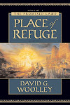
I remember reading the chapter notes in Place of Refuge about borders near and nearer, but for some reason it was the explination of near and nearer that stuck with me, not the use of the word border.
Line upon line.
Tell me, how amazing is it to be able to go to some of these Book of Mormon lands and stand there? It is something that I think must be just incredible and amazing.
Sandra:
You jumped the gun and read the inital draft. Very confusing. That was a trial ballon so I could test the interactive maps on the blog. Now go back and read the TRUE version. Its not nearly as directionally challenged. It even makes some sense. The maps are fixed. The photos are all up. Its actually readable.
Thanks for the comments.
David G. Woolley
I liked it in draft form and like it even better now. And it wasn't you that confused me, I just get confused by geography- don't ever put me in a maze unless you are deliberatly trying to lose me, because I can guarantee, I will get lost.
Still, the finished version puts it all a bit more firmly in my mind.
And you didn't tell me how amazing it is to stand in these places and see them firsthand. What does that feel like, to know that you are walking the same dirt that the ancient peoples walked?
I've spent a couple of hours now reading and re-reading the post, following the links - and links I found on the links - and pouring over the maps. I would thank you from the bottom of my heart for truly awesome and awe-inspiring post . . . if I were speaking to you. Which I am absoluteLY, certainLY, definiteLY not.
Thanks Anonymous:
I'm always concerned about getting too technical. But then I realize I have a very, very, very smart readership. These aint not whimps here at Top of the Morning.
What is really confusing about a post like this is that we're talking about territory that is unfamiliar and it takes the reader some serious concentration to get familiar with it.
Then there is that direction thing. North, south, east, west are such intangables. Throw too many of them out and pretty soon you risk confusing people.
But if you endure the confusion, it really does make the Book of Mormon come to life. You begin to understand the difficulty, loniless and long journeys of Alma. My, how he must have had a testimony to venture out into the Border lands like that.
You also get a very real sense of Kingdom, cities, and how difficult it must have been to govern people living in so many different climes, and speaking so many different dialects.
You also gain an appreciation for what happened after the coming of Christ. All these people in the Land of Zarahemla lived peacefully along with all the people living in the Lands Northrward in the the southern dwelling lands of the Lamanites. And the only administrative overseers were twelve apostles. There will be a post on that one day soon.
Thanks for reading. Hope you come back often and comment often.
All the best,
David G. Woolley
Dave, I gave the post another read (third time's the charm). It definitely is one that gets clearer the more time you take to read it through, and give the maps another try (maps not being my area of expertise ...). Thanks for the further instructions on how many clicks to get to the right level of detail -- that was helpful!
I absolutely have a new understanding now of Book of Mormon geographical terminology. Thanks for the insights.
This is an interesting perspective on how ancient geography influenced Book of Mormon storytelling.
Post a Comment